The highs — and lows — of Brookside’s El Rio del Jardin de las Flores
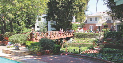
BACKYARD of Brookside home shows bridges over stream in March 2018.
Brookside’s stream, El Rio del Jardin de las Flores, has had some highs and lows over the last few years, both in the amount of water moving through the streambed, and in the ongoing research to preserve the stream.
Last September, Brookside resident Nancy Levine reached out to the Larchmont Chronicle with an update, letting us know that while the stream seems to have a normal flow where it “daylights,” just south of Wilshire Boulevard, that the flow was weak between 8th and 9th Streets, and dry where it flows south of 9th Street. Residents were also concerned about flourishing mosquito populations because of the standing water. They have been working with the Watershed Protection Division of Los Angeles Sanitation and field deputies from Council District Four to get answers. Levine contacted us and wondered if we could help.
The Chronicle covered the depletion of water in the streambed in 2017, when residents of the Brookside neighborhood first noted the decrease in water flow. Oddly enough, according to the Los Angeles Almanac, 2017 had been a year of steady winter rains after a five-year drought. At that time, residents reached out to the Los Angeles Dept. of Public Works and Councilman David Ryu’s office to begin investigation into where the water had gone.
Four reports study the problem
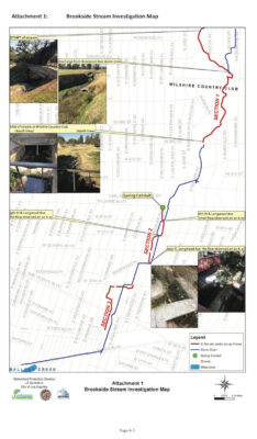
THIS PHASE 2 investigation map shows the stream above ground in three sections, beginning at Melrose Ave. near Wilcox Ave. and ending just south of San Vicente Boulevard.
After four reports by the Watershed Protection Division, several conclusions have been reached. In the Phase 1 report from March 2018, it was noted that water levels and flow rates were not consistent at all properties along S. Longwood Avenue; the stream at some properties had more water than at other properties, suggesting that there may be more locations along the Brookside Stream where groundwater was feeding the stream.
The Phase 2 report from June 2018 noted that there was a time, before the 1930s, when the brook had been connected to the storm drain system, but had been disconnected when the storm drain system had been updated. In addition, while the stream does lose some water through filtration into the ground, that amount is relatively small.
The report also noted that for there to be a consistent stream level of a half a foot of water flowing at .24 feet per second, there needed to be at least 238,500 gallons flowing through the stream per day. It was determined that the best source to replenish the stream was the dry weather runoff in the Longbrook Avenue storm drain, but there needed to be a feasibility study to see if that could work.
The Phase 3 report from November 2018 researched whether or not the Longwood Avenue storm drain could work in replenishing the stream. However, the average water runoff from that drain was 33 gallons per minute, but the stream needed a source that offered an estimated 135 gallons of water per minute. There is a second storm drain that could be used located under Wilshire Boulevard that would deliver more water, but it would take more work to connect the conduit to the spring, and cost more money.
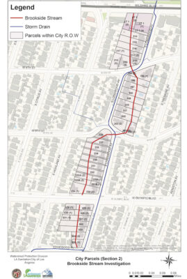
PLANNERS OF the Brookside neighborhood in 1921 developed lots around the stream, as can be seen in this Phase 4 map.
In 2019, after another winter of steady rains, the levels of the stream increased slightly — for a time — which was when the Chronicle learned from the Watershed Protection Division that the source of the brook, the natural spring fed by groundwater, had been decreasing from years of drought, and the storm drain alternatives were still being studied.
Since then, a Phase 4 study conducted in July 2019 has looked into other causes of water depletion, other problems caused by the water depletion, and what it could take to return the flow of water to the brook.
One of the possibilities that was in the Phase 4 report was that construction on Metro’s Purple Line had depleted the groundwater because of the pumping stations put into place along Wilshire Boulevard.
Michael Scaduto, an engineer with the Watershed Protection Division, pointed out that those pumping stations are not really very close to the stream, and that it is more likely that the groundwater was depleted through years of drought. He also pointed to development in the area that would siphon off some of the water. However, the pumping station is due to be removed by 2023 or 2024 and that could help with surrounding groundwater levels.
David Sotero at Metro also believed that the pumping stations were not close enough to the spring to be the cause of the depleted water levels, and that it was more likely to be a decrease in groundwater from drought.
In both cases, when I asked about the possibility of somehow infusing water back into the groundwater table after the Purple Line construction is completed, there were references to budget cuts and not knowing if there would be funding for such projects.
Other causes and issues
Three other problems noted in the Phase 4 study include water stagnation and an increase in the mosquito population, construction activities by some property owners that may be impacting the stream and the right of property owners to use water from the stream as it runs through their property.
Levine said she and other Brookside residents were particularly concerned about the increase in the mosquito population. Getting residents to clean debris out of streambeds, thus removing a possible harbor for the insects, is one solution, and also helps to increase the flow of any water running through the streambed. Obtaining mosquito fish was another suggestion.
Construction activities and making personal use of the water as it flows through backyards of some property owners also could have impacts on the stream. Because the stream is a natural watercourse, the Los Angeles Municipal Code (Sections 64.07, 64.08, 64.09 and 64.10) specifies that “…No person shall do anything to any natural water course or any channel carrying storm water that will in any manner obstruct or interfere with the flow of water through such water course or channel,” unless there has been a permit obtained from the Board of Public Works.
In the end, the question is, who is responsible for the depleted water flow in the stream? Who is responsible for bringing the water flow back up to normal levels?
The answer is that while, for the most part, each property owner is responsible for the care of his or her part of the stream, that stream is also part of a larger water system that could impact other water systems downstream, and other ecosystems. The Phase 4 study reports that while bioswales and other natural easements have been put in place in repairing other waterways, those were on public lands. There needs to be funding for such projects.
Most recently, when asked about the state of the streambed, Levine noted the flooding of the waterway after one of the rainstorms this winter, but the streambed had quickly dried up again.
Sandy Boeck, another concerned resident, noted that while she still had a dry streambed, it was good to see some neighbors cleaning up their parts of the stream.
This will not be an easy fix. The solution most likely will be a combination, or intertwining, of public and private work.
History of stream and neighborhood
The history of the stream and the neighborhood is also intertwined. According to the Windsor Square-Hancock Park Historical Society, the neighborhood of Brookside was carved out of the original Rancho Las Cienegas (Ranch of the Marshland), owned by Mexican native Don Francisco Avila.
In 1921, the Rimpau Estate Company began to sell home sites with many properties along Longwood Ave., where the developers laid out deep rear lots bisected by a natural underground stream. Not wanting the stream to run on only one side of the street, the planners developed around it, with the stream winding from one side of the street to the other, preserving some of the natural arroyos, barrancas (gorges) and hills of the original tracts.
Although it was first known as Windsor Crest, the neighborhood became known as Brookside because of the stream that ran from the Hollywood Hills to Ballona Creek.
Category: Real Estate