City redistricting moves to City Council this month
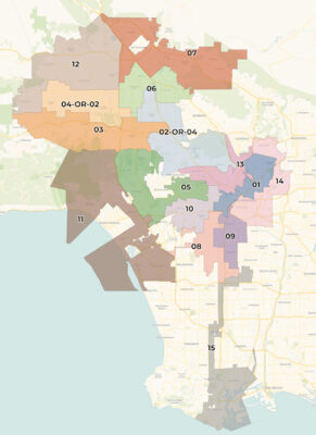
THE CITY OF LOS ANGELES is divided into 15 City Council Districts, many of them surrounding other independent cities. This is the map of new district lines being recommended by the independent Los Angeles City Council Redistricting Commission. The new district lines will be debated by the members of the City Council beginning in November, with a goal of adopting, by sometime in December, final district boundaries that will be in effect for the next decade, beginning Jan. 1, 2022.
After one year of volunteer service, plus professional staffing and paid consultants, a citizen commission has issued its recommendation for new City Council Districts and has forwarded its Final Report to the Los Angeles City Council. Every 10 years, following the national census, political district boundary lines are reevaluated across the country.
The current procedure in the City of Los Angeles is for a citizen commission to be appointed by the City Council members and the three citywide elected officials. The Mayor gets three picks; and the City Attorney and City Controller each gets one. The president of the City Council gets two picks, and the other 14 council members each get one. That is 21 total. The final map recommendation was approved by a 15 to 6 vote.
Vision and core values
This citizen commission started organizing one year ago, holding its first meeting on Nov. 19, 2020. Former longtime president of the nonprofit Weingart Foundation, Fred Ali, has served as chair of the commission. Under Ali’s leadership, commission members discussed and agreed to a vision and core values, plus a set of 10 operating principles to guide their deliberations and line-drawing (laccrc2021.org/about-us).
The goal was to impartially apply their agreed-upon guidelines to make the changes to district lines required by population changes while keeping communities of interest together to the maximum extent feasible. For example, existing Council District 4 — where about half of the Larchmont Chronicle readers reside — was created 10 years ago as a somewhat crazy, meandering district spreading from Sherman Oaks on the west to Los Feliz on the east, with only an umbilical cord of city blocks extending south through Hollywood to pick up the circa-1950s Fourth District territory between Fairfax and Western avenues. Council office staff would often (and appropriately) complain that it could be a 24-mile drive back and forth for meetings within the district.
Now, per the commission’s final map, approved on Oct. 21, that umbilical cord to south of Hollywood has been cut. The parts of Los Angeles, generally north and south of Wilshire Boulevard and west of Western Avenue, a group of contiguous neighborhoods of common interests and activities surrounding three sides of Beverly Hills, are proposed to be united in District Five.
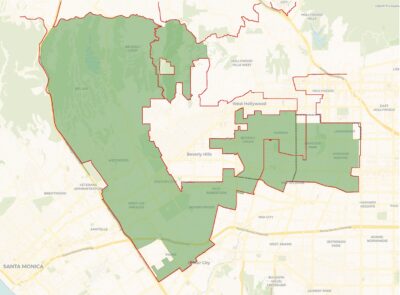
NEIGHBORHOOD COUNCILS are the main basis for the new Council District maps. The portion of proposed CD 5 that is east of Beverly Hills contains the complete Mid City West Neighborhood Council and almost all of the Greater Wilshire Neighborhood Council (GWNC). As was the case with GWNC for the past decade, GWNC will be primarily in one district, with small parts in another. Currently — of the approximately 375 city blocks in GWNC — about 46 blocks are in existing CD 5. The new proposal will have approximately 39 blocks in new CD 13 (Hollywood, to GWNC’s north), with all of the remainder being in new CD5.
And that aspect — surrounding the independent City of Beverly Hills — is one of the explanations of why the recommended overall new City Council District map looks as it does.
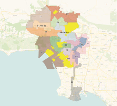
SURROUNDED CITIES are in bright yellow.
To surround cities
What do the independent cities (or Los Angeles County territory) of Inglewood, Culver City, Marina del Rey, Santa Monica, Beverly Hills, West Hollywood, Universal City, Burbank, and San Fernando have to do with the map that has been recommended?
Those cities, like the Pacific Ocean, the northern and eastern Los Angeles city limits, plus the long thin umbilical cord that connects the Port of Los Angeles to the rest of the city, are the constraints that inevitably have led to what the recommended map, and any rational map, looks like.
Our city, not surprisingly, has a large population living close to the Pacific Ocean. Los Angeles also has experienced population increases in many other parts of its 503 square miles, but there are other portions of the city where the population has decreased. An analysis of the overall map recommended by the commission shows that its professional consultants and staff dealt with these population changes while also endeavoring to follow the commission’s operating principles, including creating council districts as compact as possible, certainly more compact than what was done to Council District Four 10 years ago.
“Koreatown”
Two of the early decisions of the commission related to historical concerns about the San Fernando Valley and the area now known as “Koreatown.” For two, maybe three, decades, there has been a cry to keep the community east of Western Avenue united in a single council district (as opposed to its three, or more, districts in previous redistricting decisions).
The Valley
In the San Fernando Valley, population has continued to increase. In addition, for decades, residents there have argued that their region’s interests have not been represented adequately, because city council districts were meandering over the Santa Monica Mountains and combining communities that have different interests on either side. So, an early decision of the commission was to treat Mulholland Drive as a dividing line between Valley districts and those in the southern parts of the city, with an intention to have five complete districts, plus a substantial portion of a sixth district, contained within the San Fernando Valley. The commission-recommended map does this.
Now, back to the matter of “surrounding other cities.” A close look at the map of all 15 proposed districts shows how that was a factor affecting the recommendations.
CD 5 is a “surrounder,” surrounding most of Beverly Hills, as well as the southern part of narrow West Hollywood. Similarly, at the top of the San Fernando Valley, CD 7 surrounds the independent City of San Fernando.
Burbank
The remaining, substantial northern municipal intrusion into the territory of the City of Los Angeles comes from the City of Burbank.
On three sides, Burbank is surrounded by Los Angeles — on Burbank’s north, west and south. In the earliest version of the adopted “Plan K2.5,” the commission staff recommended surrounding those three sides of Burbank with a single council district, starting with Griffith Park on the south and then moving north, ultimately to the Shadow Hills community.
During the extensive oral testimony and through email and online feedback received by the commission subsequent to its release of the initial proposed Draft Plan K in the third week of September, there was substantial comment about the details of almost all of the 15 proposed new districts. With respect to the district proposed to surround Burbank on three sides, starting with Griffith Park on the south, the lines gradually were changed to become what finally was adopted. Burbank now touches two “completely-in-the-Valley” City of Los Angeles council districts (numbers 6 and 7) as well as the Griffith Park district to Burbank’s south (still known, as of October, as number “2-OR-4”). That district also completely surrounds the independent Universal City.
There were many hearings and much public testimony at meetings (including when, for at least one of the hearings, the commission allowed anybody who called to speak for a minute until there were no more callers). Although many of the people who called in to testify, especially later in the months-long process, advocated for keeping a favored councilmember or presented other arguments about the politics involved in recent or future elections, the commission seemed to stay true to its charge to come up with districts as compact as possible, combining communities of interest and not violating statutes governing fair voting.
Now, this month and through December 15, it will be interesting to see what the 15 (or 14 currently serving) elected city council members do with the recommendation of the independent citizen commission. After all, unlike for the state of California, which has a totally independent commission, the final say in the City of Los Angeles comes from the City Council. Stay tuned.
Category: News