The ‘Places’ — Wilton, Gramercy, St. Andrew’s and Manhattan
 As we continue our study of Greater Wilshire’s potential historic districts, let us head east to look at two surviving pockets of our community’s earliest developments that survive along that noble sounding thoroughfare of St. Andrew’s Place. The Gramercy Place-St. Andrew’s Place Residential Historic District (between 2nd and 3rd streets) and the smaller St. Andrew’s Residential Historic District (between Council and 1st streets), are two high Craftsman remnants of what were originally among the area’s first neighborhoods along the “Places,” which included neighboring Wilton Place, as the city jumped its boundaries over Western Avenue into Rancho La Brea. They were identified by SurveyLA as among the most intact clusters of our community’s residential development from this early period.
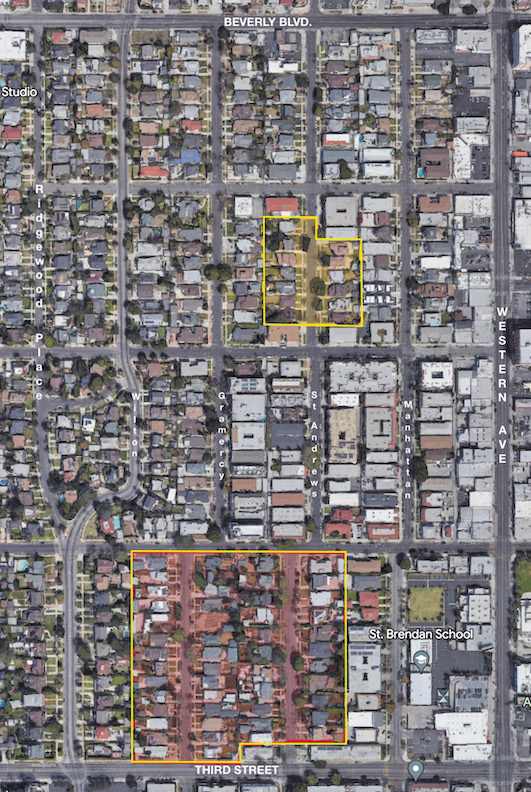
WEST OF WESTERN, historic “Places” include Gramercy and St. Andrews, as well as Ridgewood and Wilton.
According to Patt Morrison of the Los Angeles Times, Western Avenue was laid out by the county in 1853 and at that time was the horizon of the city, far away from the bustle of the old Pueblo and the rough and tumble of Downtown. By the turn of the last century, the city was rapidly expanding, and the street had become an unofficial western boundary of the city (Hoover Street being the actual boundary until 1896 when the annexation of the Western Addition pushed the boundary to Arlington Avenue, followed by the annexation of Colegrove in 1909 which pushed the boundary roughly to June Street).
As the population of Los Angeles grew and the reach of the Pacific Electric expanded, the wide plains and vistas of the now accessible Rancho La Brea beckoned developers looking to cash in. In 1901, W.G. Nevin took advantage of 1899’s third relocation to the west of the Los Angeles Country Club (to Pico Boulevard and Western Avenue) — today’s Country Club Park neighborhood — to plant his flag over the border and start his western subdivision. Here Nevin laid out these two- block-long “Places:” Manhattan Place, Gramercy Place, Wilton Place, and, in a nod to the Los Angeles Country Club, St. Andrew’s Place, named for the oldest golf course in the world, the Old Course at St. Andrew’s, Scotland.
The “Places” would move north (and south) helping define new subdivisions in what had originally been the eastern half of Plummer Square, between Temple Street (Beverly Boulevard) and Second Street (Third Street). Many of these new subdivisions decided to riff on the idea of the new “west,” with names such as Westfields (1909), Westminster (1907) and Western Place (1906), with the exception of Wilton Place (1907) and Barton Heights (1909).
These subdivisions were soon filling up with new one- and two-story craftsman style homes of the finest quality. Developed in a very suburban manner, the parcels of these subdivisions were arranged on rectilinear streets with uniform setbacks and detached garages as well as concrete sidewalks, driveways and steps.
These earlier neighborhoods were soon eclipsed as new tracts were opened up including the subdivisions of Windsor Square, Fremont Place, Ridgewood Park, Country Club Park and Wilshire Crest, all further removed from Western Avenue. By the 1930s, many of the single-family homes along the “Places” began to give way to multifamily residences to take advantage of the Western Avenue streetcar including such buildings as 210 N. St. Andrew’s Pl., designed by the first woman to become a registered architect in Los Angeles, Edith Northman. This trend would intensify in the ensuing decades until entire neighborhoods bordering Western had been transformed by apartment buildings. Today between Beverly and Third, about 50 percent of the buildings are multifamily.
While having changed significantly from its original single-family craftsman character, the “Places” still contain a wealth of historic resources — from the Wilton Historic District, along with its six individually designated City of Los Angeles Historic Cultural Monuments (HCMs), to the collection of other HCMs along the “Places.” Those include the Ganahl House by A.C. Martin (1913); the J.A. Howsley House by Henry J. Knauer (1914); as well as the B.H. Hiss House (1916) and the Borgmeyer Residence (1912). To these we now add the SurveyLA-identified St. Andrew’s Place Residential Historic District, described as a “significant concentration of Arts and Crafts residential architecture in the Wilshire area, with high quality design and craftsmanship conveyed by individual homes.” Also, a Gramercy Place – St. Andrew’s Place Residential Historic District is an “excellent example of early 20th century streetcar suburbanization in the Wilshire area, developed due to its proximity to streetcar lines that historically served the area.”
Preservation of this area would be difficult under any scenario. As long as the city continues to act as if Historic Preservation Overlay Zones (HPOZs) run afoul of 2019’s State Senate Bill 330, preservation protections are not currently an option. As with my previous suggestion about Ridgewood Place, it would be optimal to add the Gramercy Place – St. Andrew’s Place Residential Historic District to the Wilton Place Historic District because they share a common border, similar periods of significance and development patterns. The small St. Andrew’s District would either require revisiting its boundaries and contributors to make it also contiguous with Wilton Place or be its own mini-district. But as its stands now, the easiest way to add some level of preservation would be the creation of two National Register or California State Districts, or a combination of the two.
This is part of a series on neighborhood areas deserving historic preservation status.
Category: Real Estate