Who ever said L.A. doesn’t have weather? Meet our Santa Ana winds
The Santa Ana winds are a weather phenomenon unique to Southern California, just as the nor’easters are to the upper East Coast, tropical cyclones are to Florida, and tornados are to the Midwest.

UCLA Professor of Atmospheric and Oceanic Sciences, and Director of Meteorology Dr. Janine A. Baijnath-Rodino.
We are a city encircled by the Transverse Ranges, with the San Gabriel Mountains in the northeast, the Santa Susana in the northwest, the Verdugo Mountains in the north, Puente and San Jose Hills in the east, and the Santa Ana Mountains in the southeast. They protect us from the cold continental air masses and freezing desert temperatures. This wall of mountains, along with the mild temperatures of the Pacific Ocean, gift L.A. a Mediterranean climate. Angelenos stand in T-shirts and shorts while they marvel at the snow-covered San Gabriel Mountains in winter. It’s the Cajon Pass that funnels in our Santa Ana winds.
Dr. Janine A. Baijnath-Rodino, UCLA professor of atmospheric and oceanic sciences and director of meteorology, offered the science on where these mostly winter winds generate from: “Santa Ana winds often occur in Southern California during the cold season, from September through May. Air descends the mountains of Southern California [through the Cajon Pass] and brings warm, dry, strong winds—a key factor in fire weather during this time. The winds increase oxygen, which feeds flames, causing fires to grow more intense and spread more rapidly.
“To understand how Santa Ana winds work, we need to understand three main factors: pressure, temperature, and humidity.
“When it comes to pressure and wind dynamics, we need to zoom out from the earth (1,000 to 10,000 km) and look at the bigger weather systems that meteorologists refer to as the ‘synoptic scale.’ At this spatial scale, we can look at regions of high and low pressure.
“During the cold months, high pressure is situated in the Great Basins near Nevada, while low pressure is off the coast of California. Surface pressure is the force of air over a given region. A region of high pressure means that there is greater force of air in that region (think of it as air molecules colliding with the surface), compared to a region of low pressure, where there are less air molecules colliding with the surface.
“High pressure is associated with sinking air, spinning in a clockwise direction, while low pressure is associated with rising air, spinning in a counterclockwise direction.
“Cold, dense air tends to sink and produce higher pressure at the surface. In the winter, this high pressure is seen over the Great Basins and high deserts. At the same time, the ocean temperatures are relatively warmer, and the air will want to rise, producing a region of lower pressure just off California’s coast.
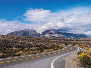
TRANSVERSE RANGES, the mountains that surround the L.A. basin, include the Santa Ana Mountains. With the Pacific Ocean they provide the double-edged sword of beautiful weather and aggressive dry winds.
Photo by Schwingi
“Naturally, Earth wants to be in a state of equilibrium, so air will move from a region of high pressure to low pressure. [More relevant topics including Coriolis force, pressure gradient force, and friction are explained on her YouTube channel, @jibber JABR!].
“Over the Great Basin, that air mass is dry and doesn’t hold a lot of moisture. As this cold, dry air mass moves from high pressure (Great Basins) toward low pressure (toward California’s coast), it descends the complex mountain ranges in California.
“That sinking air mass undergoes what meteorologists call adiabatic warming. This is a thermodynamic process where the air mass does not exchange heat with the surroundings but will warm up because the air compresses. What is happening is that the air mass is compressed by the surrounding greater atmospheric pressure. When the air mass compresses, the pressure inside the air increases, thereby increasing the temperature in the air mass—warm winds form.
“One other characteristic of the Santa Ana winds is the increased dryness that occurs as it descends the mountains (called saturation vapor pressure).
“Warmer air has a greater saturation vapor pressure (it can hold more water than cold air). Therefore, during a Santa Ana wind event, when the air compresses and warms adiabatically, but no more water vapor is added or removed, the air mass will naturally become drier. This is why Santa Ana winds can be dangerous—they enhance the warming and dryness of the air, which can be detrimental during wildfire season.”
So, how is one lured into this world of science? Dr. Baijnath-Rodino said, “When I was 4, I moved from Guyana, a warm tropical country in South America, to Ontario Canada, a cold, snowy climate heavily influenced by the Laurentian freshwater Great Lakes. The Great Lakes were snow machines during the early winter months. The relatively warm lake waters and the cold arctic air mass above, mixed to produce blizzards and snowstorms, called lake effect snowfall, that inundated cities along the leeward side of the Great Lakes.
“While pursuing my master’s and Ph.D., I was also a television meteorologist for the Canadian Broadcasting Corporation. I quickly realized how challenging it was to forecast these snowstorms and the limitations with weather models (what we call numerical weather prediction models). This challenge helped motivate my Ph.D. research in understanding the climatological and meteorological factors influencing lake-effect snowfall.
“When I moved to California, I found it funny when some of the locals had never heard about freezing rain but were very comfortable living among wildfires. I still study the physics of the atmosphere but apply it to wildfire dynamics.”
Not everyone in SoCal enjoys what some refer to as devil winds (a common phrase referring to our winds, possibly made from the portmanteau of Santa Anas, Santanas—bearing a resemblance to “Satan”). They can fuel fires and ignite allergies. Others look forward to the warm, clear, star-filled nights these winds bring. But without the ring of mountains that surround L.A. (which funnel in these warm, dry winds), we would have a climate more like San Francisco—lots of cold marine coastal fog. Don’t forget the phrase, “The coldest winter I ever spent was a summer in San Francisco.” So don’t fight the winds—adjust your sails!
You can watch Baijnath-Rodino’s science show at linktr.ee/jibberjabr, or on youtube.com/watch?v=BHoBU1JcSmQ.
Category: People